Category:Monasteranenagh Abbey
Jump to navigation
Jump to search
| Object location | | View all coordinates using: OpenStreetMap |
|---|

|
This object is indexed in the Archaeological Survey of Ireland under SMR No. LI031-050004-
Geographic information system of the National Monuments Service: Historic Environment Viewer – Database record. |
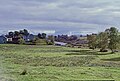
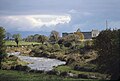
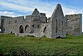
medieval friary and National Monument located in County Limerick, Ireland  | |||||
| Upload media | |||||
| Instance of | |||||
|---|---|---|---|---|---|
| Location | County Limerick, Munster, Ireland | ||||
| Heritage designation | |||||
| Inception |
| ||||
| Dissolved, abolished or demolished date |
| ||||
 | |||||
Media in category "Monasteranenagh Abbey"
The following 19 files are in this category, out of 19 total.
-
 Manister Cross 1987.jpg 4,184 × 2,787; 4.71 MB
-
 Monasteranenagh 01.png 1,904 × 1,244; 3.03 MB
-
 Monasteranenagh 02.png 1,909 × 1,276; 3.34 MB
-
 Monasteranenagh 03.png 1,089 × 933; 1.75 MB
-
 Monasteranenagh 04.png 633 × 816; 928 KB
-
 Monasteranenagh 05.png 742 × 861; 1.04 MB
-
 Monasteranenagh 06.png 1,006 × 486; 818 KB
-
 Monasteranenagh 07.png 737 × 756; 968 KB
-
 Monasteranenagh 08.png 962 × 920; 1.3 MB
-
 Monasteranenagh 09.png 771 × 545; 738 KB
-
 Monasteranenagh 10.png 2,048 × 3,136; 6.07 MB
-
 Monasteranenagh Abbey 1987a.jpg 6,400 × 4,304; 22.09 MB
-
 Monasteranenagh Abbey 1987b.jpg 6,384 × 4,304; 7.3 MB
-
 Monasteranenagh Abbey 1987c.jpg 4,256 × 2,901; 5.44 MB
-
 Monasteranenagh Abbey exterior 1987.jpg 4,267 × 2,869; 5.93 MB
-
 Monasteranenagh Abbey historical marker 1987.jpg 2,848 × 4,309; 2.05 MB
-
 Monasteranenagh Abbey interior 1987.jpg 2,827 × 4,288; 2.96 MB
-
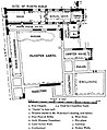 Monasteranenagh Abbey Plan.jpg 616 × 750; 66 KB
-
 MonasteranenaghAbbey.jpg 4,224 × 3,168; 4.61 MB


Categories:
- Objects of County Limerick recorded in the Archaeological Survey of Ireland with known IDs
- Cistercian abbeys in Ireland
- Monasteries in County Limerick
- 1140s monasteries in Ireland
- Cistercian monasteries established in the 1140s
- Monasteries established in 1148
- Monasteries disestablished in 1539
- Ruins of Romanesque churches in Ireland
- 12th-century churches in Ireland
- Architectural basilicas in Ireland